


SPECIALIZING IN GEOSPATIAL
Advanced geospatial intelligence hardware and software solutions that utilizes imagery from satellite and aerial sources to identify, analyze, and extract ground features, allowing for rapid product creation. Image analysis, advanced photogrammetric techniques, remote sensing, and feature collection workflows are seamlessly combined into one streamlined package.
15784-3d-pv-fhd
15785-3d-pv-fhd-24
14815-3d-pv-2.5k
16140-3d-pv-uhdm
3d-pv-2.5k
3d-pv-uhdm
14821
15352
14815
14943
15784
15785
14815
16140
3d-pv-fhd
3d-pv-3.5k
3d-pv-uhdm
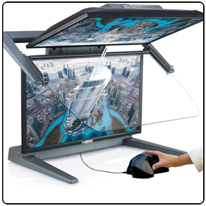
PluraView by Schneider Digital
3D Display Excellence – High-end PluraView Stereo
Flicker-free and high-resolution visualization for the perfect 3D stereo experience
Key Features:
Flicker-free for relaxed 3D operations and continuous, professional use
Highest brightness – suitable for office daylight conditions, one monitor per stereo channel and each eye
Free and wide viewing angle – suitable for group viewings with up to 5 people
Highest resolution - up to 4K (UHD) with 8.3 MegaPixel per eye at 10-bit color depth
Certified for several hundred applications (PDF listed on 3D-Pluraview.com)
Engineered and manufactured with the highest quality in Germany
Future-proof and established for more than 17 years as plug & play technology
Our best stereo-reference are many long-term and highly satisfied users
GIS APPLICATIONS
GIS & 3D Mapping
Photogrammetry & LiDAR
Oil & Gas Prospecting & Simulation
Mine Planning and Open-Pit Monitoring
Mechanical Design / CAD / CAM
Archeology, cultural heritage documentation
3D City Model Visualization
BIM and Architecture Modeling
Flow & Light Simulation
Computer Tomography & Surgical Planning
Industrial Measuring / Laser Scanning / Tomography